Keeling Curve

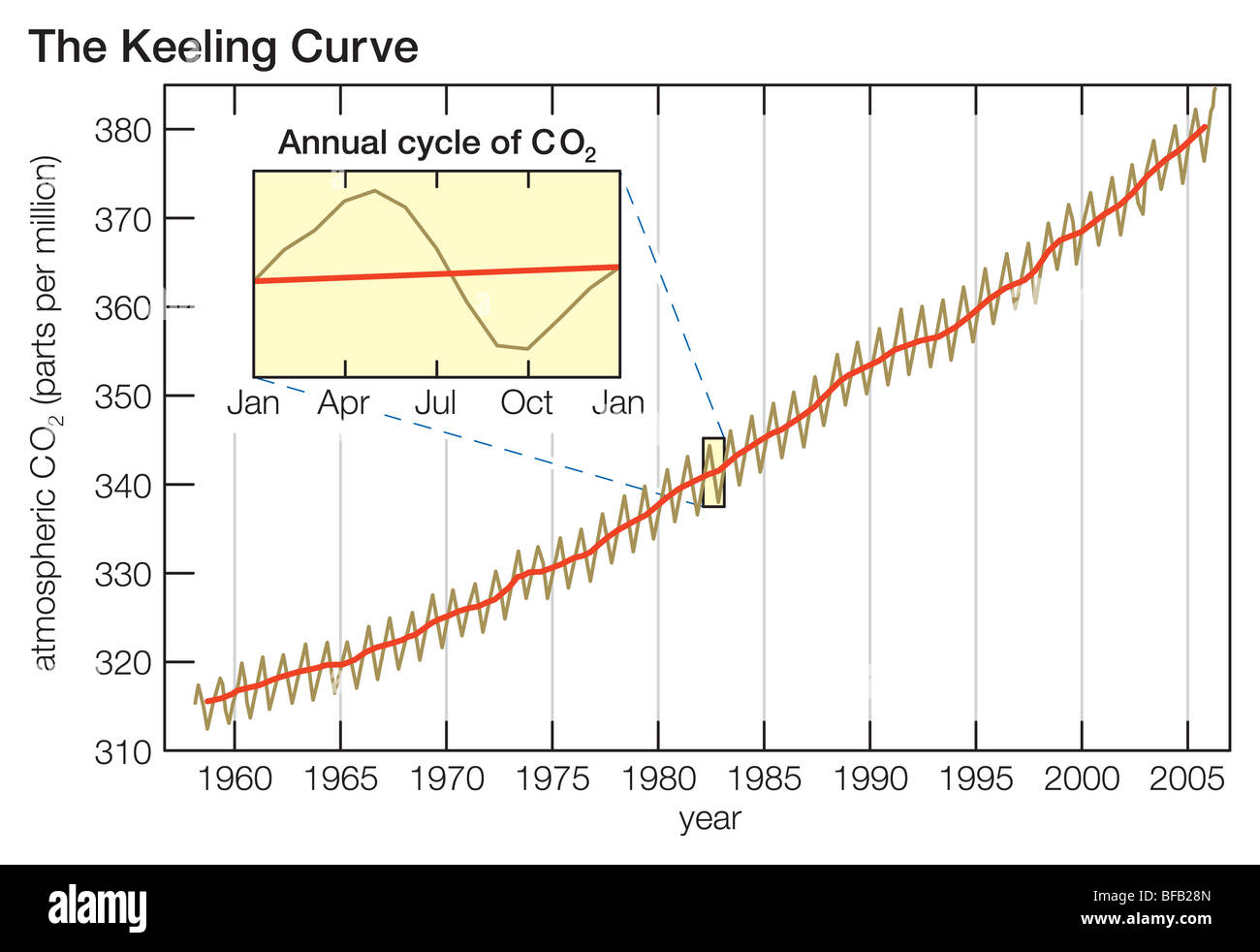
The Keeling Curve is a graph of the accumulation of carbon dioxide in the earths atmosphere based on continuous measurements taken at the Manua Loa  Obsorvatory on the island of Hawaii from 1958 to the present day. The curve is named for the scientist Charles david  Keeling, who started the monitoring program and supervised it until his death in 2005.

Keeling’s measurements showed the first significant evidence of rapidly increasing carbon dioxide levels in the atmosphere According to Dr Naomi Oereskes Professor of History of Science at Harvard University the Keeling curve is one of the most important scientific works of the 20th century Many scientists credit the Keeling curve with first bringing the world’s attention to the current increase of carbopn dioxide in the atmosphere.

Bildergebnis für keeling curve

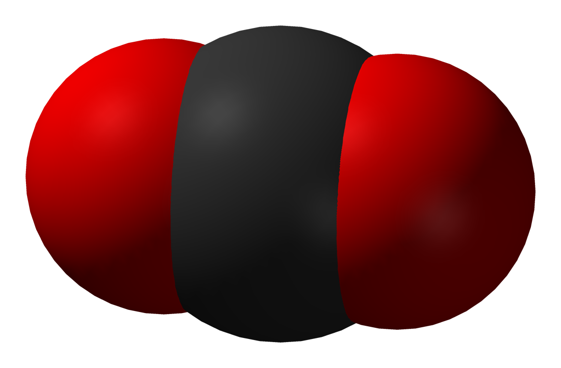
Carbon dioxide, or CO2, is a very common, naturally occurring molecule that contains two oxygen atoms and one carbon atom. In everyday conditions on Earth, carbon dioxide is a commonly occurring gas that is all around us. It is colourless, odourless, is naturally present in Earth’s atmosphere and is an important part of Earth’s carbon cycle. All humans and animals exhale carbon dioxide when they breathe, and plants absorb it during a process called photosynthesis in order to grow.

Bildergebnis für carbon dioxide


Greenhouse gases are gases that can trap heat. They get their name from greenhouses. A greenhouse is full of windows that let in sunlight. That sunlight creates warmth. The big trick of a greenhouse is that it doesn’t let that warmth escape.


Bildergebnis für Greenhouse gasses


Daniel Horn 9BL1

Heat Transfer

Heat transfer is the generation, use, conversion, and exchange of thermal energy (heat) between physical systems. Heat transfer is classified into various mechanisms, such as, advection, conduction, convection, radiation, and transfer of energy by phase changes.


Advection

By transferring matter, energy is moved by the physical transfer of a hot or cold object from one place to another. This can be as simple as placing hot water in a bottle and heating a bed, or the movement of an iceberg in changing ocean currents.


Conduction

Heat conduction occurs as hot, rapidly moving or vibrating atoms and molecules interact with neighboring atoms and molecules, transferring some of their energy to these neighboring particles. In other words, heat is transferred by conduction when adjacent atoms vibrate against one another, or as electrons move from one atom to another. For example A radiator is a type of conduction. Anything placed on the radiator, like clothing, will become warm.


Convection

Convection, is the transfer of heat from one place to another by the movement of fluids, a process that is essentially the transfer of heat via mass transfer. When fluids are moving, heat is transferred from one place to another. convection can be demonstrated by placing a heat source (e.g. a Bunsen burner) at the side of a glass filled with a liquid, and observing the changes in temperature in the glass caused by the warmer fluid circulating into cooler areas.


Radiation

Thermal radiation occurs through a vacuum or any transparent medium (solid or fluid or gas). It is the transfer of energy by means of photons in electromagnetic waves governed by the same laws. Thermal radiation is energy emitted by matter as electromagnetic waves, due to the pool of thermal energy in all matter with a temperature above absolute zero. Thermal radiation propagates without the presence of matter through the vacuum of space. Radiation is a direct result of the random movements of atoms and molecules in matter. Since these atoms and molecules are composed of charged particles (protons and electrons), their movement results in the emission of electromagnetic radiation, which carries energy away from the surface. Examples are x-rays from an x-ray machine or ultraviolet light emmited from the sun.

Download

By Leon Bederov 9BL2

Conduction and Convection

Conduction is a process in which transfer of heat takes place between objects by direct contact.
The conduction represents how heat travels between objects in direct contact. The cause is due to the temperature difference. Conduction occurs in solids, through molecular collisions. The speed of conduction is slow.

Conduction: HOW DOES IT WORK
When molecules (of two different solids) are adjacent with each other, the molecules of one of the solids are hot, meaning that they will vibrate and bump into the molecules of the solid next to them, causing them to gain energy like a chain. So then both molecules are vibrating and have spread and transferred the heat.


Convection refers to the form of heat transfer in which energy transition occurs within the fluid. Convection represents how heat passes through fluids. The cause is due to density difference. Convection occurs in fluids, by actual flow of matter. Convection transfers heat using intermediate substance. The speed is slow too.

Convection: HOW DOES IT WORK
When there is a heat source in a place with air or liquid, the heat source heats up the liquid and/or gas which causes it to rise since the molecules start moving faster, meaning that the heated up liquid or gas are moving is less dense than the air around it. The molecules inside that liquid or gas are moving a lot faster and are bouncing around, zooming around randomly. Since it is less dense, the denser air or liquid pushes up against the warm air causing it to rise up. The warm air then cools when it gets up and gets denser, causing it to fall. And from there, the warm air gets heated again and the whole cycle starts again. This cycle is called convection and can happen anywhere where there is liquid or gas and a heat source.

The water molecules are free to move around and this form convection currents and try to bring the water to a uniform temperature.
Heat is transferred through conduction from the flame or heated or heat source is at a distance from the vessel, radiation also would come into play

by Helin Karatur, Sena Bayraktar 9BL2

The Weather Fronts

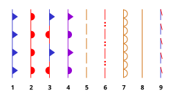
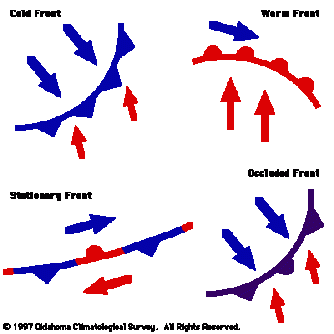
There are nine types of fronts, but the main ones are the occluded front, the stationary front, the warm front and last but not least, the cold front. What is a front? The weather front has nothing to do with the front row of the cinema or the front side of an object like a book or a box. A weather front is a transition zone between two air masses. For example the cold air mass or the warm air mass. The picture below shows the symbols that represent the nine fronts and their names.

  1. Cold front
  2. Warm front
  3. Stationary front
  4. Occluded front
  5. Surface trough
  6. Squall/shear line
  7. Dry line
  8. Tropical wave
  9. Trowal

The Four Main Fronts

Before we look into the four main fronts, I will tell you why these four fronts are the main ones. There is one simple reason and it is, because they are the most common ones.

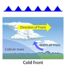
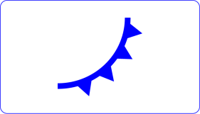
The Cold Front                                                                                                                                         Cold Front The cold front is represented with blue triangles on a blue line.  The cold front moves twice as fast as the warm front. The cold front is formed when the cold air mass pushes under a warm air mass, forcing the warm air to rise. The cold front usually brings storms and also sharp changes in the weather appear and as the cold air moves it brings cold weather. 
The Warm Front 

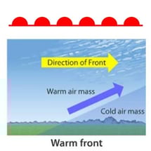
Warm Front The warm front is represented with a red line on which there are red half circles. Before the warm front comes to us, there are clouds and the closer the front is, the bigger the chance is to rain. Sometimes it might also start to snow. There might be also a fog, before the warm front reaches us. When the front comes to us, the temperature rapidly warms up and the clouds start to clear up. The warm front is formed when a warm air mass slides up and over a cold air mass.
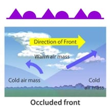
The Occluded Front                                                                                                                                Occluded Front The occluded front is shown as a purple line with half circles and triangles on it. The occluded front occurs when the warm air mass gets caught between two cold air masses. As the cold air masses move towards each other, they push the warm air and it is rising up. This continues until the cold air masses meet in the middle and as a result they push up completely the warm air.
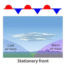
The Stationary Front                                                                                                                               Stationary FrontThe stationary front is shown as a red and blue line. The red line has red half circles on it and the blue one has blue triangles on it. In the stationary front neither the warm or the cold air moves. They remain stationary. Winds blow in opposing directions on each side. The weather is dry and clear, however, if there is moisture near the fronts, it might start to rain and clouds will appear.
 

The Movement of the Warm and Cold Front

It is hard to predict the movement of the fronts, because they extend for hundreds miles and not all portions of the front will move at the same speed. And also throughout the  day, they move at a different speed.

The Warm Front                                                                                                                                  The warm front moves toward the northeast at an average of 18, 5 kph. It is hard to predict the movement of the warm front, due to the reason that the front speeds up during the day and during the night, it slows down.

The Cold Front                                                                                                                                      The cold front moves toward the southeast. The speed of the front depends on whether it is an active cold front, which means a slow moving front, or an inactive front, a fast moving front. The active front moves at an average of 28 kph and the inactive front moves with 46 kph.


By Ralitsa Mineva 9BL1

The Four Weather Fronts


Hello readers and welcome to my blog about the four weather fronts. They are going to be explained in my blog.

Fronts


What are air masses and weather fronts?

The properties and movements of air masses are responsible for all the weather patterns we experience in daily life. An air mass is a large body of air, with similar temperature and moisture content throughout. And a weather front is a boundary between air masses with different properties. It is a zone of transmission between two different air masses. The type of the front depends on the direction in which the air mass is moving. There are four fronts: cold, warm, occluded and stationary fronts.

Cold Front

It is defined as the transmission zone where a cold air mass is replacing a warmer air mass. The cold front forms when a cold air mass pushes under a warm air mass, forcing the warm air to rise. The air behind the cold front is usually colder and drier than the air ahead of the front. Cold fronts move always from northwest to southeast. When a cold front passes through, the temperature can drop more than 15 degrees within the first hour.

The cold fronts are always drawn with a solid blue line with triangles along the front pointing towards the warm air and in the direction of moment.

COLD-SYMBOLS

Warm Front

The warm front is defined as the transmission zone where a warm air mass is replacing a cold air mass. It forms when a moist, warm air mass slides up and over a cold air mass. And the air behind the warm front is warmer and moister than the air ahead of it. When a warm front passes through, the air becomes noticeably warmer and more humid than it was before. Warm fronts usually move from southwest to northeast, so it is the opposite of the cold front.

A warm front is drawn with a solid red lime with semicircles pointing towards the colder air and in the direction at movement.

warm_front

Occluded Front

An occluded front is a weather front formed during the process of “cyclogenesis”, which means when a cold front over takes a warm front. When the warm front is separated (occluded) from the cyclone center at the Earth’s surface. It is the point where warm front and occluded front meet. It is so-called “triple point”.

In other words, as the storm intensifies, the cold front rotates around the storm and catches the warm front and this forms an occluded front. It forms when a warm air mass gets caught between two cold air masses. The warm air mass rises as the cool air masses push and meet in the middle.

Occluded front are always drawn with a solid purple line with altering triangles and circles, pointing the direction the front s moving.

OCCLUDED-SYMBOLS

Stationary Front

A stationary front is a pair of air masses, neither of which is strong enough to replace the other.

A wide variety of weather can be found along a stationary front, but usually clouds, prolonged precipitation, and storm trains are found there.

Stationary front will either dissipate after several days or devolve into sheer lines, but it can change to warm front or cold front if conditions aloft change. It forms when warm and cold airs meet, and neither air mass has the force to move the other. They remain stationary, or “standing still”. It is represented by alternating blue and red lines with blue triangles pointing towards the warm air and red semicircles pointing towards the colder air.

sfdef1

This is how the fronts are represented in a weather map.

noaa-weather-synoptic-map

//1R.C

Rayan Chahrour 9BL1

Specific Heat

What is specific heat?

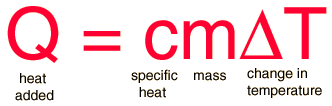
Specific heat is the amount of heat per unit mass required to raise the temperature by one degree Celsius.T he relationship between heat and temperature change is usually expressed in the form shown below where c is the specific heat. The relationship does not apply if a phase change is encountered, because the heat added or removed during a phase change does not change the temperature.


Specific heat is equivalent to the heat capacity of a unit mass of a substance or the heat needed to raise the temperature of one gram (g) of a substance one degree Celsius. Water requires about 4 to 5 times more heat energy to raise its temperature when compared to an equal mass of most types of solid matter. This explains why water bodies heat more slowly than adjacent land surfaces. The specific heat of water is 1 calorie/gram °C = 4.186 joule/gram °C which is higher than any other common substance. As a result, water plays a very important role in temperature regulation. The specific heat per gram for water is much higher than that for a metal, as described in the water-metal example. For most purposes, it is more meaningful to compare the molar specific heats of substances.The molar specific heats of most solids at room temperature and above are nearly constant, in agreement with the Law of Dulong and Petit. At lower temperatures the specific heats drop as quantum processes become significant. The low temperature behavior is described by the Einstein-Debye model of specific heat.

The Law of Dulong and Petit explain the specific heat of solid:

The specific heat of copper is 0.093 cal/gm K (.389 J/gm K) and that of lead is only 0.031 cal/gm K(.13 J/gm K). Why are they so different? The difference is mainly because it is expressed as energy per unit mass; if you express it as energy per mole, they are very similar. It is in fact that similarity of the molar specific heats of metals which is the subject of the Law of Dulong and Petit. The similarity can be accounted for by applying equipartition of energy to the atoms of the solids.From just the translational degrees of freedom you get 3kT/2 of energy per atom. Energy added to solids takes the form of atomic vibrations and that contributes three additional degrees of freedom and a total energy per atom of 3kT. The specific heat at constant volume should be just the rate of change with temperature (temperature derivative) of that energy.

It also gives the specific heat of gases, about which I will tell more now.The specific heats of gases are generally expressed as molar specific heat. For a monoatomic ideal gas the internal energy is all in the form of kinetic energy, and kinetic theory provides the expression for that energy, related to the kinetic temperature. The expression for the internal energy is


Nicos Weege 9BL2

Aerosols


Hello readers and welcome to our blog about aerosols.

Firstly, what are Aerosols?

Aerosols are tiny solid liquid particles that are dispersed into gasesous system. Most aerosols reflect the suns radient energy into space and therefore cool the earth’s climate. Other aerosols can have warming effect on the climate. These aerosols, called brown carbon or black carbon, absorb and reflect light, which makes it difficult to determine how much they affect the earth’s climate.

The different types of Aerosols:

There are two types of aerosols, natural and anthropogenic aerosols. Natural aerosls are classified into two types that depend on their mechanism of formation. These are called primary and secondary atmospheric aerosols. Primary atmospheric aerosols are generated directly by a natural source such as smoke and soot from wildfires, desert dust and ocean waves whipping sea salt into the atmosphere. secondary atmospheric aerosols are formed in the atmosphere by condensation. An example of this is sulfur dioxide gas emitte by a volcanic eruption. Once high up in Earth’s atmosphere, the sulfur dioxide gas is actually converted to droplets of sulfuric acid.  90% of aerosols in our atmosphere have a natural origin.

Anthropogenic aerosols, however, are all aerosols that are human-made. Thesecan be the result of burning  fossil fuels and other examples are haze, particulate air pollutants and smoke.

799E4998-B00D-4692-A130-2A4644D05A0COur Modell: A powerplant that produces athropogenic aerosols by burning fossil fuels for example. (We built a powerplant and a smoke-bomb. Then we placed the smoke-bomb in the powerplant and lit the smoke-bomb.)


While aerosols can influence climate by scattering light and changing Earth’s reflectivity they can also affect the climate via clouds.

Aerosoles and clouds:

Aerosols attend as condensation and ice microbes on which clouds droplets and ice particles can form. Aerosols change the number and size and distribution of the droplets in clouds. If there are more aerosol particles clouds of water droplets tend to have more and smaller droplets causing the cloud cover to intensify and more solar radiation is reflected.

Aersoles and the sky:

Aerosols can also influence the colors of the sky according to their type and situation. If there are many soot particles in the air, they have an effect on the scattering of the light and thus the sky appears gray and hazy.

At sunrise and sunset, aerosols also affect the red color of the sky. Molecules retain the blue and green parts of the light, making the sky look reddish. Aerosols reinforce this once again. So the more aerosols in the air, the stronger the color.

Can Aerosols reduce or even stop climate change?

First of all: the anthropogenic enhancement of the greenhouse effect causes less solar radiation to be reflected into space, so the earth‘s albedo is lowered. More solar radiation is absorbed, which means more radiation is converted to long-wave radiation. This stays therefore longer in the atmosphere, so that it comes to a warming.

Although aerosols have virtually no influence on the long-wave radiations. But they reflect the solar radiation and partly absorb it. As a result, less long-wave radiation reaches the earths ground and thus there is a cooling. But on the other hand they absorb the rays and this wams the atmosphere.

However, the lifetime of aerosols in the atmosphere is much shorter than that of greenhouse gases. The lifetime of aerosols is several days and that of greenhouse gases is decades to centuries. The cooling effect can last for a short period of time, but the effect of greenhouse gases lasts much longer.

But so far you do not know much about the actual effects of aerosols. However, the fact is that they mask the greenhouse effect, but there was still a rise in global temperature. One recognizes that aerosols probably never stop the ever-advancing greenhouse effect. Aerosols can therefore delay but not prevent the impending climate catastrophe.

//Made by Laura and Tia

Weather Fronts

Hello reader and welcome to my blog about Weather fonts. There are three main weather fronts which I am going to talk about, called the Cold front, Warm front, Occluded front and the Stationary front.


What are weather fronts?

A weather front is a boundary separating two masses of air of different densities, and is the principal cause of meteorological phenomena outside the tropics. In surface weather analyses, fronts are depicted using various colored triangles and half-circles, depending on the type of front. The air masses separated by a front usually differ in temperature and humidity.


Cold front

If cold air is moving toward warm air, then it is a [cold front]. Cold fronts (always shown as a blue line) with arrow points on it. It can be defined as a front in which a cold air mass is replacing a warm air mass at the surface. A cold front is located at the leading edge of the temperature drop off, which in an isotherm analysis shows up as the leading edge of the isotherm gradient, and it normally lies within a sharp surface trough. Cold fronts often bring heavy thunderstorms, rain, and hail. They also can produce superfast changes in weather and move up to two times faster than warm fronts.

Characteristics of a cold front:

  • The air behind a cold front is noticeably colder and drier than the air ahead of it.
  • Cold fronts can be associated with cirrus clouds well ahead of the front, strong thunderstorms along and ahead of the front, and a vast area of clouds immediately behind the front.
  • Cold fronts can bring the most violent weather among the different types of fronts.

fronti5t.png


Warm front

A warm (always shown as a red line) front can be defined as a front in which a warm air mass is replacing a colder air mass at the surface. Warm fronts occur along the leading edge of warm air masses. Along warm fronts, warm air displaces cold air and following the passage of a warm front, the temperature rises. Warm air is less dense than cold air and thus lots of warm air has to rise up and over the cold air mass before the cold gives way. Because of this as well as the shallow slope of the frontal surface, the lifting along and ahead of the warm front is usually gradual and thus results in a large area of light to moderate rain. Remember that the atmosphere is three dimensional and that fronts aren’t just a surface phenomenon. Fronts extend well up into the atmosphere and form  “surfaces” that air parcels are forced to interact with. The slopes of these surfaces are important in determining what impacts a front may have.

Characteristics of a warm front:

  • The slope of a warm front is much more gradual than a cold front.
  • Warm fronts typically move much slower than cold fronts.
  • Warm fronts can be associated with cirrus, altostratus, altocumulus, and stratus clouds as well as occasional fog.
  • Warm fronts typically produce less violent weather than cold fronts.
  • Clouds and precipitation are quite prevalent ahead of the warm front.

fronti17t.png


Occluded front

An occluded front (always shown in purple) is formed when a cold front overtakes a warm front, and usually forms around mature low-pressure areas. The cold and warm fronts curve naturally pole ward into the point of occlusion, which is also known as the triple point. It lies within a sharp trough, but the air mass behind the boundary can be either warm or cold. In a cold occlusion, the air mass overtaking the warm front is cooler than the cool air ahead of the warm front and plows under both air masses. In a warm occlusion, the air mass overtaking the warm front is warmer than the cold air ahead of the warm front and rides over the colder air mass while lifting the warm air.

images.png


Stationary front

A stationary front (always shown in red and blue) is a non-moving boundary between two air masses, neither of which is strong enough to replace the other. They tend to remain essentially in the same area for extended periods of time, usually moving in waves. There is normally a broad temperature gradient behind the boundary with more widely spaced isotherm packing.

A wide variety of weather can be found along a stationary front, but usually clouds and prolonged precipitation are found there. Stationary fronts either dissipate after several days or devolve into shear lines, but they can transform into a cold or warm front if conditions aloft change. Stationary fronts are marked on weather maps with alternating red half-circles and blue spikes pointing in opposite directions, indicating no significant movement.download.jpg


By Can Sevim 9BL2


Benifits and Harms in the Troposphere, Stratosphere and Earth’s surface

Stratosphere

This layer is 35 kilometers thick. The stratosphere is where you’ll find the very important ozone layer. The ozone layer helps protect us from ultraviolet radiation (UV) from the sun therefore it is a benefit for all organisms. In fact, the ozone layer absorbs most of the UV radiation the sun sends to us. Life as we know wouldn’t be possible without this layer of protection.

The ozone is created primarily by ultraviolet radiation. When high-energy ultraviolet rays strike ordinary oxygen molecules (O2), they split the molecule into two single oxygen atoms, known as atomic oxygen. A freed oxygen atom then combines with another oxygen molecule to form a molecule of ozone. There is so much oxygen in our atmosphere, that these high-energy ultraviolet rays are completely absorbed in the stratosphere.

The stratosphere is actually around the whole earth. In 2016, the NASA found out that currents of high air circulate in the atmosphere around the planet and these winds can affect everything from earth’s protecting ozone layer to where pollutants end up. Some scientist think the shift might be due to global warming or the El Niño.

Troposphere

Ozone in the troposphere acts as a greenhouse gas and therefore it’s harmful to the environment. Nearly all of the water vapor and dust particles in the atmosphere are in the troposphere. That is why most clouds are found in this lowest layer, too. The Troposphere also has their own ozone layer, but tropospheric ozone is a short-lived climate pollutant with an atmospheric lifetime of hours to weeks. It does not have any direct emissions sources, rather it is a secondary gas formed by the interaction of sunlight with hydrocarbons, including methane, and nitrogen oxides, which are emitted by vehicles, fossil fuel power plants, and other man-made sources.

In the troposphere, ozone is the product of the atmospheric reaction of a number of pollutants, which have both natural and man-made sources. Pollutants created by human activities include hydrocarbons and nitrogen oxides, which are largely emitted by cars and other vehicles, fossil fuel power plants, oil refineries, the agriculture sector and a number of other industries.

Increases in tropospheric ozone lead to a warming of Earth’s surface because ozone is a greenhouse gas. The negative effects of excess tropospheric ozone contrast sharply with the protection from harmful UV-B radiation afforded by an abundance of stratospheric ozone.

 Earth’s surface

Ozone near Earth’s surface in excess of natural amounts is considered as bad ozone. It is formed by reactions involving human-made pollutant gases like CO2. Increasing surface ozone above natural levels is harmful to humans, plants, and other living systems because ozone reacts strongly to destroy or alter many biological molecules. High ozone exposure reduces crop yields and forest growth. In humans, exposure to high levels of ozone can reduce lung capacity; cause chest pains, throat irritation, and coughing; and worsen preexisting health conditions related to the heart and lungs. When ozone levels rise in the summertime athletes are advised to avoid training outside in the afternoon as the ozone could damage the lungs.

By Alexander Schloz 9BL2


The path of air on a mountain

UNADJUSTEDNONRAW_thumb_1a7.jpg

Hello Readers! This blog is about the different temperatures along the path of a mountain.

The first question we ask ourselves when it comes to mountains is why it is much colder the higher we get on a mountain, even though the sun is closer to the top of the mountain.

Very naive you would come up with the idea to suspect it would be warmer because you come closer to the sun. The sun is 150 million km away however, while the highest mountains only reach a height of just under 9 km. So, you quickly realize that this idea is very far-fetched.

There is another consideration with the sun where short-wave radiation reaches the ground and is absorbed. At the same time the ground of the earth sends long-wave heat radiation. This radiation provides heating for the lower layers of air. Especially on hot summer days you can see this radiation as a glimmer on roads. But is that the real reason the air gets colder with Height?

No. It has nothing to do with the sun because the little difference in altitude doesn’t make any difference. It rather has to do with air pressure. Air is made up of small particles that move. Because of this movement it occurs that these particles rub against each other and collide. But what does that have to do with temperature? Quite simply, the more pressure you apply, the faster the particles move. But a faster movement leads to a higher temperature.So: As the air pressure decreases with altitude, it slows down the particle movement and so the temperature decreases. The air pressure keeps on decreasing the higher we get on the mountain.

The sun heats up the land, in the valley and on the mountain. The ground radiates heat and heats up the air around. The warm air rises, because it is lighter than cold air. In the valley, the heated air warms the whole environment.
Unlike on the mountain. When warm air rises from the ground, it cools down quickly. However, with increasing distance from the sea level, the air gets thinner and thinner and thus all molecules become less common, including oxygen. Here warm air expands quickly. It cools down. It’s possible that snow still exists on top of the mountains in summer but the associated loss of oxygen can be dangerous to people who are in high altitudes.

The next topic I want to write about is the weather on mountains and how it effects the surrounding land.

Mountain tops are often hidden by clouds and often people get lost in the clouds when they want to hike. But why does that even happen?

Clouds are formed by the condensation of water vapor in rising air. Air is very moist which means it holds lots of water when it is near the sea or when it is constantly raining. Most of the time, clouds cover all mountain tops because the bottom of the cloud, which is called cloud base, is often below 1,000 meters.

Strong winds at the mountain top can blow heavier rain over the mountain top, so the heaviest rain will not necessarily be at the highest point. If people want to go on a hike waterproof clothing and footwear on mountains is essential as there can be heavy rain, driving winds and mountain streams.

Heavy rain occurs on mountains when winds carry moist air over the land. This air reaches the mountain and it rises because the mountain is in the way. The air cools down as it rises. This cool air can carry not as much moisture as warm air, resulting in precipitation.

The higher up the mountain we climb, the colder and windier it gets. For example: On the Munros (the Scottish mountains with tops above 3,000 meters) it is possible that it is 10°C cooler at the top of the mountain in comparison to the valley below. In fact, air can cool by 6°C in every 1,000 meters. But why does it get windier? It is windy high up in the atmosphere as the effect of gravity is reduced. Over the Himalayas winds of 150km per hour are not uncommon!

Snow in combination with poor visibility due to clouds also causes problems because shadows disappear. Navigation becomes almost impossible and can lead to walking to dangerous places even over the edges of cliffs. This is known as a ‚whiteout‘. In conclusion, the climate varies from top to bottom along a mountain.

What are the effects on the environment near mountains?

Mountains can influence the climate of nearby land. In some areas rain gets blocked by mountains, so that one side of a mountain range may be rainy and the other side may be a desert. These sides are called the windward side and the leeward side.

The windward side faces into the direction the wind is coming from. The leeward side is the opposite side which is protected against wind.

Much of the moisture transported by wind falls as rain on the windward side of mountains. This creates the effect called the “rain shadow”, when the other side which is called the leeward side, gets far less rain. This often produces a desert. The higher the mountain, the more pronounced the rain shadow effect. Leeward sides of mountains are often drier than windward sides because by the time the air with the moisture reaches the leeward side, it has already lost some of the moisture.

A fun fact: Many deserts are created because of the lack of moisture which is blocked by the mountains.

Now, let’s talk about wildlife and plants.

There can be different ecosystems on each side of the mountain, which you can encounter in the Rocky Mountains. But also, there can be different ecosystems when you climb up the mountain due to the changes in altitude. While the vegetation depends on precipitation and temperature, the vegetation at the bottom of the mountain largely depends on the climate zone. Higher up a mountain, it gets colder as explained before, and the trees sooner or later disappear. The `tree line´ is the barrier when it gets too cold for trees to grow.

In the highest parts of mountains there can only be found grasses and alpine flowers which are adapted to the conditions. But often the vegetation completely disappears and the top is covered in snow.

Goats and Bears are common on mountains. They are adapted to the extreme conditions. Food is scarce and it is freezing cold. However, there can also be mountain lions, antelope and sheep depending on the specific continent.

The picture above show a model which represents a mountain. The differently-colored flags show the temperatures. From the red until the ski-colored flag, it is nicely warm. To the blue flag it gets cool and above the blue flag, it is very cold. There is also snow on the mountain which represents the coldness.

By Kiera Weise from 9BL2